|
|
|||||||||||||||||
| Point ID: 317 | Downloads | Plots | Site Data | Code: 05BL020 |
|
|
|||||||||||||||||
| Download | |
|---|---|
| Site Descriptor Information | Site Time Series Data |
| Link to all available data | |
| View: | Time Series | All |
| Units: | mm |
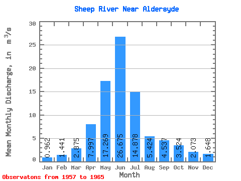
| Statistic | Jan | Feb | Mar | Apr | May | Jun | Jul | Aug | Sep | Oct | Nov | Dec | Annual |
|---|---|---|---|---|---|---|---|---|---|---|---|---|---|
| Mean | 0.96 | 1.44 | 2.88 | 8.00 | 17.27 | 26.68 | 14.88 | 5.42 | 4.54 | 3.52 | 2.07 | 1.65 | 6.87 |
| Standard Deviation | 0.42 | 1.02 | 1.99 | 6.56 | 7.00 | 12.93 | 10.74 | 2.60 | 2.83 | 2.61 | 1.04 | 0.92 | 1.40 |
| Min | 0.32 | 0.27 | 1.27 | 2.20 | 8.10 | 15.00 | 5.62 | 2.55 | 1.79 | 1.55 | 1.00 | 0.70 | 5.45 |
| Max | 1.56 | 3.34 | 6.98 | 19.30 | 26.20 | 48.80 | 31.40 | 10.40 | 11.80 | 9.72 | 4.03 | 3.59 | 9.17 |
| Coefficient of Variation | 0.44 | 0.70 | 0.69 | 0.82 | 0.41 | 0.48 | 0.72 | 0.48 | 0.62 | 0.74 | 0.50 | 0.56 | 0.20 |
 Return to R-Arctic Net Home Page