|
|
|||||||||||||||||
| Point ID: 3132 | Downloads | Plots | Site Data | Code: 06FD002 |
|
|
|||||||||||||||||
| Download | |
|---|---|
| Site Descriptor Information | Site Time Series Data |
| Link to all available data | |
| View: | Time Series | All |
| Units: | mm |
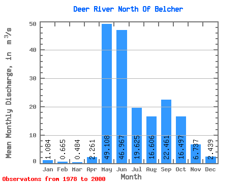
| Statistic | Jan | Feb | Mar | Apr | May | Jun | Jul | Aug | Sep | Oct | Nov | Dec | Annual |
|---|---|---|---|---|---|---|---|---|---|---|---|---|---|
| Mean | 1.08 | 0.67 | 0.48 | 2.26 | 49.11 | 46.97 | 19.62 | 16.61 | 22.46 | 16.50 | 6.74 | 2.44 | 14.88 |
| Standard Deviation | 0.66 | 0.38 | 0.28 | 5.02 | 30.08 | 32.56 | 15.24 | 13.99 | 22.55 | 14.97 | 5.57 | 2.06 | 6.33 |
| Min | 0.18 | 0.06 | 0.02 | 0.01 | 3.23 | 19.50 | 3.92 | 2.66 | 2.69 | 3.27 | 1.61 | 0.54 | 6.98 |
| Max | 2.75 | 1.37 | 1.07 | 18.00 | 109.00 | 164.00 | 60.40 | 48.90 | 79.00 | 69.40 | 23.40 | 9.84 | 28.03 |
| Coefficient of Variation | 0.61 | 0.58 | 0.58 | 2.22 | 0.61 | 0.69 | 0.78 | 0.84 | 1.00 | 0.91 | 0.83 | 0.84 | 0.42 |
 Return to R-Arctic Net Home Page