|
|
|||||||||||||||||
| Point ID: 3129 | Downloads | Plots | Site Data | Code: 06FB002 |
|
|
|||||||||||||||||
| Download | |
|---|---|
| Site Descriptor Information | Site Time Series Data |
| Link to all available data | |
| View: | Time Series | All |
| Units: | mm |
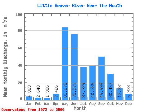
| Statistic | Jan | Feb | Mar | Apr | May | Jun | Jul | Aug | Sep | Oct | Nov | Dec | Annual |
|---|---|---|---|---|---|---|---|---|---|---|---|---|---|
| Mean | 4.06 | 2.65 | 1.99 | 7.43 | 83.68 | 75.97 | 37.73 | 40.39 | 50.00 | 30.45 | 13.38 | 6.92 | 29.09 |
| Standard Deviation | 2.51 | 1.68 | 1.26 | 11.68 | 46.28 | 35.90 | 25.17 | 39.27 | 42.98 | 19.57 | 7.62 | 4.02 | 9.98 |
| Min | 0.55 | 0.39 | 0.22 | 0.10 | 16.60 | 30.80 | 12.00 | 4.59 | 2.69 | 4.54 | 2.10 | 0.83 | 14.03 |
| Max | 9.57 | 6.08 | 4.05 | 52.40 | 231.00 | 205.00 | 130.00 | 178.00 | 168.00 | 84.40 | 32.20 | 14.60 | 50.45 |
| Coefficient of Variation | 0.62 | 0.64 | 0.63 | 1.57 | 0.55 | 0.47 | 0.67 | 0.97 | 0.86 | 0.64 | 0.57 | 0.58 | 0.34 |
 Return to R-Arctic Net Home Page