|
|
|||||||||||||||||
| Point ID: 312 | Downloads | Plots | Site Data | Code: 05BL015 |
|
|
|||||||||||||||||
| Download | |
|---|---|
| Site Descriptor Information | Site Time Series Data |
| Link to all available data | |
| View: | Time Series | All |
| Units: | mm |
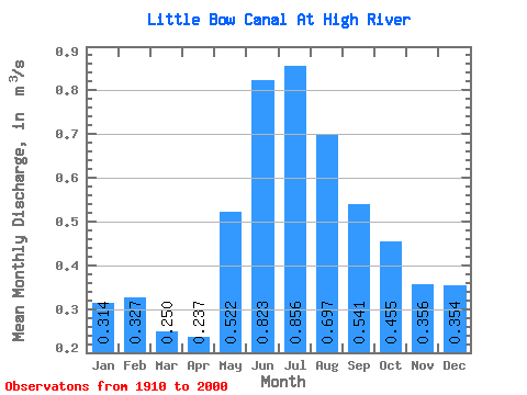
| Statistic | Jan | Feb | Mar | Apr | May | Jun | Jul | Aug | Sep | Oct | Nov | Dec | Annual |
|---|---|---|---|---|---|---|---|---|---|---|---|---|---|
| Mean | 0.31 | 0.33 | 0.25 | 0.24 | 0.52 | 0.82 | 0.86 | 0.70 | 0.54 | 0.46 | 0.36 | 0.35 | 0.63 |
| Standard Deviation | 0.24 | 0.26 | 0.30 | 0.30 | 0.59 | 0.86 | 0.76 | 0.51 | 0.39 | 0.37 | 0.34 | 0.25 | 0.35 |
| Min | 0.00 | 0.00 | 0.00 | 0.00 | 0.00 | 0.00 | 0.01 | 0.00 | 0.00 | 0.00 | 0.00 | 0.00 | 0.01 |
| Max | 0.84 | 1.03 | 1.36 | 1.31 | 2.26 | 2.99 | 2.70 | 1.92 | 1.40 | 1.91 | 1.95 | 0.88 | 1.16 |
| Coefficient of Variation | 0.77 | 0.79 | 1.20 | 1.25 | 1.14 | 1.04 | 0.88 | 0.73 | 0.72 | 0.81 | 0.95 | 0.70 | 0.56 |
 Return to R-Arctic Net Home Page