|
|
|||||||||||||||||
| Point ID: 3114 | Downloads | Plots | Site Data | Code: 05UF006 |
|
|
|||||||||||||||||
| Download | |
|---|---|
| Site Descriptor Information | Site Time Series Data |
| Link to all available data | |
| View: | Time Series | All |
| Units: | mm |
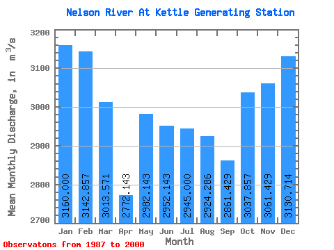
| Statistic | Jan | Feb | Mar | Apr | May | Jun | Jul | Aug | Sep | Oct | Nov | Dec | Annual |
|---|---|---|---|---|---|---|---|---|---|---|---|---|---|
| Mean | 3160.00 | 3142.86 | 3013.57 | 2772.14 | 2982.14 | 2952.14 | 2945.00 | 2924.29 | 2861.43 | 3037.86 | 3061.43 | 3130.71 | 2998.63 |
| Standard Deviation | 495.30 | 483.22 | 517.31 | 603.27 | 617.52 | 1067.51 | 1161.82 | 953.65 | 658.73 | 601.64 | 495.67 | 470.41 | 555.83 |
| Min | 2230.00 | 2240.00 | 2180.00 | 1970.00 | 2080.00 | 1690.00 | 1780.00 | 1600.00 | 1850.00 | 1820.00 | 2110.00 | 2300.00 | 2224.17 |
| Max | 4040.00 | 3950.00 | 3810.00 | 3920.00 | 4410.00 | 5420.00 | 5370.00 | 4860.00 | 4130.00 | 3780.00 | 3890.00 | 3980.00 | 4194.17 |
| Coefficient of Variation | 0.16 | 0.15 | 0.17 | 0.22 | 0.21 | 0.36 | 0.40 | 0.33 | 0.23 | 0.20 | 0.16 | 0.15 | 0.18 |
 Return to R-Arctic Net Home Page