|
|
|||||||||||||||||
| Point ID: 3096 | Downloads | Plots | Site Data | Code: 05TD001 |
|
|
|||||||||||||||||
| Download | |
|---|---|
| Site Descriptor Information | Site Time Series Data |
| Link to all available data | |
| View: | Time Series | All |
| Units: | mm |
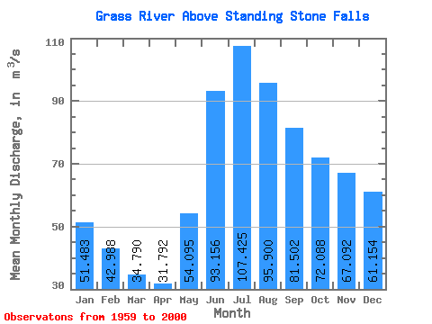
| Statistic | Jan | Feb | Mar | Apr | May | Jun | Jul | Aug | Sep | Oct | Nov | Dec | Annual |
|---|---|---|---|---|---|---|---|---|---|---|---|---|---|
| Mean | 51.48 | 42.99 | 34.79 | 31.79 | 54.09 | 93.16 | 107.42 | 95.90 | 81.50 | 72.09 | 67.09 | 61.15 | 66.33 |
| Standard Deviation | 23.15 | 17.68 | 12.11 | 9.32 | 20.06 | 41.04 | 48.66 | 41.97 | 32.46 | 29.59 | 30.57 | 28.05 | 21.49 |
| Min | 15.20 | 14.20 | 13.30 | 12.90 | 22.90 | 23.80 | 22.30 | 29.20 | 22.40 | 18.30 | 19.00 | 16.50 | 24.73 |
| Max | 102.00 | 76.80 | 57.90 | 51.40 | 103.00 | 194.00 | 237.00 | 228.00 | 187.00 | 138.00 | 149.00 | 132.00 | 119.78 |
| Coefficient of Variation | 0.45 | 0.41 | 0.35 | 0.29 | 0.37 | 0.44 | 0.45 | 0.44 | 0.40 | 0.41 | 0.46 | 0.46 | 0.32 |
 Return to R-Arctic Net Home Page