|
|
|||||||||||||||||
| Point ID: 3092 | Downloads | Plots | Site Data | Code: 05SC002 |
|
|
|||||||||||||||||
| Download | |
|---|---|
| Site Descriptor Information | Site Time Series Data |
| Link to all available data | |
| View: | Time Series | All |
| Units: | mm |
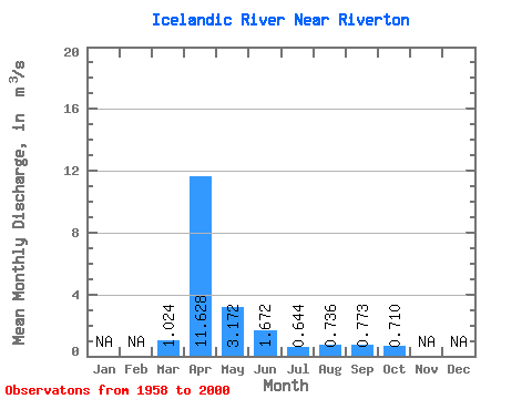
| Statistic | Jan | Feb | Mar | Apr | May | Jun | Jul | Aug | Sep | Oct | Nov | Dec | Annual |
|---|---|---|---|---|---|---|---|---|---|---|---|---|---|
| Mean | 1.02 | 11.63 | 3.17 | 1.67 | 0.64 | 0.74 | 0.77 | 0.71 | |||||
| Standard Deviation | 2.52 | 11.57 | 4.21 | 2.94 | 0.56 | 1.71 | 1.62 | 0.81 | |||||
| Min | 0.01 | 0.70 | 0.28 | 0.20 | 0.09 | 0.06 | 0.10 | 0.18 | |||||
| Max | 15.60 | 49.80 | 21.50 | 18.50 | 3.20 | 9.40 | 9.92 | 3.57 | |||||
| Coefficient of Variation | 2.46 | 0.99 | 1.33 | 1.76 | 0.86 | 2.33 | 2.10 | 1.15 |
 Return to R-Arctic Net Home Page