|
|
|||||||||||||||||
| Point ID: 3091 | Downloads | Plots | Site Data | Code: 05SB005 |
|
|
|||||||||||||||||
| Download | |
|---|---|
| Site Descriptor Information | Site Time Series Data |
| Link to all available data | |
| View: | Time Series | All |
| Units: | mm |
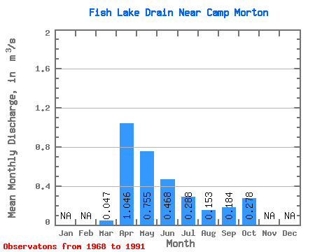
| Statistic | Jan | Feb | Mar | Apr | May | Jun | Jul | Aug | Sep | Oct | Nov | Dec | Annual |
|---|---|---|---|---|---|---|---|---|---|---|---|---|---|
| Mean | 0.05 | 1.05 | 0.76 | 0.47 | 0.29 | 0.15 | 0.18 | 0.28 | |||||
| Standard Deviation | 0.10 | 1.36 | 1.00 | 0.58 | 0.42 | 0.22 | 0.30 | 0.42 | |||||
| Min | 0.00 | 0.00 | 0.00 | 0.00 | 0.00 | 0.00 | 0.00 | 0.00 | |||||
| Max | 0.43 | 5.82 | 3.75 | 2.02 | 1.59 | 0.84 | 1.07 | 1.57 | |||||
| Coefficient of Variation | 2.03 | 1.30 | 1.33 | 1.24 | 1.46 | 1.46 | 1.66 | 1.51 |
 Return to R-Arctic Net Home Page