|
|
|||||||||||||||||
| Point ID: 3054 | Downloads | Plots | Site Data | Code: 05OJ009 |
|
|
|||||||||||||||||
| Download | |
|---|---|
| Site Descriptor Information | Site Time Series Data |
| Link to all available data | |
| View: | Time Series | All |
| Units: | mm |
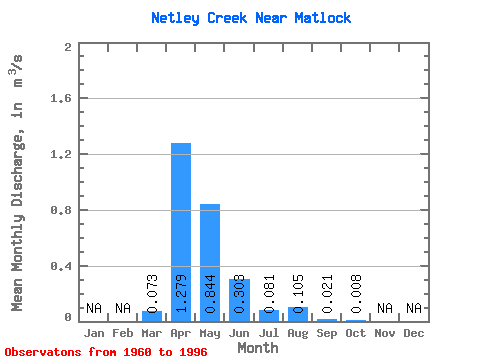
| Statistic | Jan | Feb | Mar | Apr | May | Jun | Jul | Aug | Sep | Oct | Nov | Dec | Annual |
|---|---|---|---|---|---|---|---|---|---|---|---|---|---|
| Mean | 0.07 | 1.28 | 0.84 | 0.30 | 0.08 | 0.10 | 0.02 | 0.01 | |||||
| Standard Deviation | 0.16 | 1.53 | 1.63 | 0.61 | 0.16 | 0.23 | 0.05 | 0.02 | |||||
| Min | 0.00 | 0.00 | 0.00 | 0.00 | 0.00 | 0.00 | 0.00 | 0.00 | |||||
| Max | 0.78 | 7.44 | 7.26 | 2.94 | 0.60 | 0.83 | 0.19 | 0.07 | |||||
| Coefficient of Variation | 2.18 | 1.20 | 1.93 | 2.01 | 2.01 | 2.22 | 2.52 | 2.32 |
 Return to R-Arctic Net Home Page