|
|
|||||||||||||||||
| Point ID: 3050 | Downloads | Plots | Site Data | Code: 05OJ002 |
|
|
|||||||||||||||||
| Download | |
|---|---|
| Site Descriptor Information | Site Time Series Data |
| Link to all available data | |
| View: | Time Series | All |
| Units: | mm |
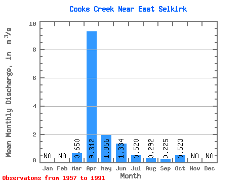
| Statistic | Jan | Feb | Mar | Apr | May | Jun | Jul | Aug | Sep | Oct | Nov | Dec | Annual |
|---|---|---|---|---|---|---|---|---|---|---|---|---|---|
| Mean | 0.65 | 9.31 | 1.96 | 1.33 | 0.52 | 0.29 | 0.23 | 0.52 | |||||
| Standard Deviation | 1.43 | 8.42 | 3.84 | 1.67 | 1.14 | 0.73 | 0.62 | 2.49 | |||||
| Min | 0.00 | 0.05 | 0.00 | 0.00 | 0.00 | 0.00 | 0.00 | 0.00 | |||||
| Max | 5.43 | 31.30 | 20.90 | 6.79 | 6.14 | 3.01 | 2.70 | 14.80 | |||||
| Coefficient of Variation | 2.20 | 0.90 | 1.96 | 1.25 | 2.20 | 2.50 | 2.77 | 4.77 |
 Return to R-Arctic Net Home Page