|
|
|||||||||||||||||
| Point ID: 3049 | Downloads | Plots | Site Data | Code: 05OH009 |
|
|
|||||||||||||||||
| Download | |
|---|---|
| Site Descriptor Information | Site Time Series Data |
| Link to all available data | |
| View: | Time Series | All |
| Units: | mm |
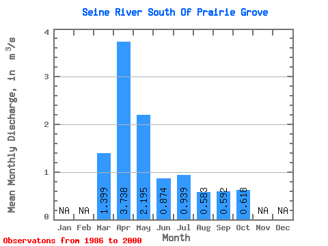
| Statistic | Jan | Feb | Mar | Apr | May | Jun | Jul | Aug | Sep | Oct | Nov | Dec | Annual |
|---|---|---|---|---|---|---|---|---|---|---|---|---|---|
| Mean | 1.40 | 3.74 | 2.19 | 0.87 | 0.94 | 0.58 | 0.59 | 0.62 | |||||
| Standard Deviation | 2.13 | 3.65 | 2.25 | 0.46 | 0.90 | 1.03 | 1.00 | 0.98 | |||||
| Min | 0.01 | 0.72 | 0.49 | 0.13 | 0.09 | 0.01 | 0.00 | 0.02 | |||||
| Max | 7.25 | 12.60 | 8.42 | 1.82 | 3.11 | 3.56 | 2.90 | 3.43 | |||||
| Coefficient of Variation | 1.52 | 0.98 | 1.02 | 0.53 | 0.96 | 1.77 | 1.69 | 1.59 |
 Return to R-Arctic Net Home Page