|
|
|||||||||||||||||
| Point ID: 3045 | Downloads | Plots | Site Data | Code: 05OH003 |
|
|
|||||||||||||||||
| Download | |
|---|---|
| Site Descriptor Information | Site Time Series Data |
| Link to all available data | |
| View: | Time Series | All |
| Units: | mm |
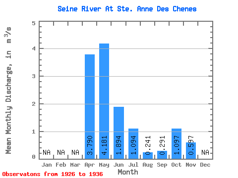
| Statistic | Jan | Feb | Mar | Apr | May | Jun | Jul | Aug | Sep | Oct | Nov | Dec | Annual |
|---|---|---|---|---|---|---|---|---|---|---|---|---|---|
| Mean | 3.79 | 4.18 | 1.89 | 1.09 | 0.24 | 0.29 | 1.10 | 0.60 | |||||
| Standard Deviation | 6.02 | 2.10 | 2.11 | 0.37 | 0.24 | 1.56 | |||||||
| Min | 3.79 | 0.82 | 0.31 | 0.06 | 0.01 | 0.14 | 0.21 | 0.60 | |||||
| Max | 3.79 | 20.70 | 7.18 | 7.05 | 1.26 | 0.87 | 5.41 | 0.60 | |||||
| Coefficient of Variation | 1.44 | 1.11 | 1.93 | 1.53 | 0.82 | 1.43 |
 Return to R-Arctic Net Home Page