|
|
|||||||||||||||||
| Point ID: 3040 | Downloads | Plots | Site Data | Code: 05OG006 |
|
|
|||||||||||||||||
| Download | |
|---|---|
| Site Descriptor Information | Site Time Series Data |
| Link to all available data | |
| View: | Time Series | All |
| Units: | mm |
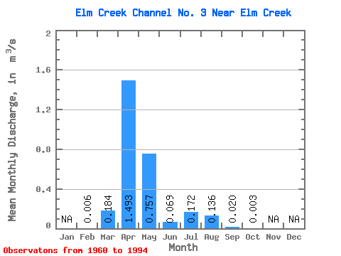
| Statistic | Jan | Feb | Mar | Apr | May | Jun | Jul | Aug | Sep | Oct | Nov | Dec | Annual |
|---|---|---|---|---|---|---|---|---|---|---|---|---|---|
| Mean | 0.01 | 0.18 | 1.49 | 0.76 | 0.07 | 0.17 | 0.14 | 0.02 | 0.00 | ||||
| Standard Deviation | 0.45 | 1.75 | 1.83 | 0.16 | 0.47 | 0.32 | 0.06 | 0.01 | |||||
| Min | 0.01 | 0.00 | 0.00 | 0.00 | 0.00 | 0.00 | 0.00 | 0.00 | 0.00 | ||||
| Max | 0.01 | 2.10 | 6.27 | 7.22 | 0.79 | 1.83 | 1.08 | 0.24 | 0.02 | ||||
| Coefficient of Variation | 2.44 | 1.17 | 2.42 | 2.30 | 2.75 | 2.34 | 3.19 | 2.31 |
 Return to R-Arctic Net Home Page