|
|
|||||||||||||||||
| Point ID: 3038 | Downloads | Plots | Site Data | Code: 05OG004 |
|
|
|||||||||||||||||
| Download | |
|---|---|
| Site Descriptor Information | Site Time Series Data |
| Link to all available data | |
| View: | Time Series | All |
| Units: | mm |
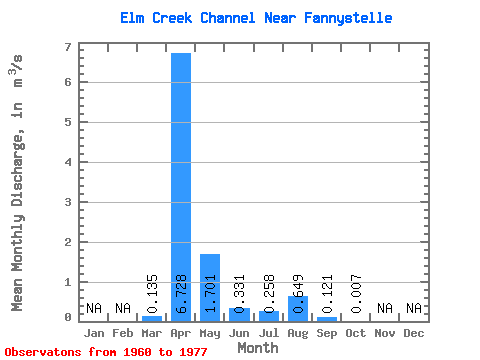
| Statistic | Jan | Feb | Mar | Apr | May | Jun | Jul | Aug | Sep | Oct | Nov | Dec | Annual |
|---|---|---|---|---|---|---|---|---|---|---|---|---|---|
| Mean | 0.14 | 6.73 | 1.70 | 0.33 | 0.26 | 0.65 | 0.12 | 0.01 | |||||
| Standard Deviation | 0.28 | 5.82 | 3.06 | 0.56 | 0.72 | 1.47 | 0.26 | 0.02 | |||||
| Min | 0.00 | 0.02 | 0.01 | 0.00 | 0.00 | 0.00 | 0.00 | 0.00 | |||||
| Max | 0.98 | 18.40 | 11.90 | 2.20 | 2.92 | 4.98 | 0.86 | 0.05 | |||||
| Coefficient of Variation | 2.08 | 0.87 | 1.80 | 1.69 | 2.78 | 2.27 | 2.16 | 2.37 |
 Return to R-Arctic Net Home Page