|
|
|||||||||||||||||
| Point ID: 3028 | Downloads | Plots | Site Data | Code: 05OF016 |
|
|
|||||||||||||||||
| Download | |
|---|---|
| Site Descriptor Information | Site Time Series Data |
| Link to all available data | |
| View: | Time Series | All |
| Units: | mm |
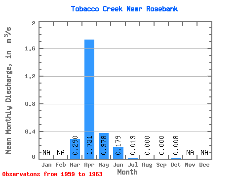
| Statistic | Jan | Feb | Mar | Apr | May | Jun | Jul | Aug | Sep | Oct | Nov | Dec | Annual |
|---|---|---|---|---|---|---|---|---|---|---|---|---|---|
| Mean | 0.29 | 1.73 | 0.38 | 0.18 | 0.01 | 0.00 | 0.00 | 0.01 | |||||
| Standard Deviation | 0.34 | 1.79 | 0.53 | 0.19 | 0.02 | 0.00 | 0.00 | 0.02 | |||||
| Min | 0.00 | 0.10 | 0.00 | 0.00 | 0.00 | 0.00 | 0.00 | 0.00 | |||||
| Max | 0.83 | 4.73 | 1.31 | 0.45 | 0.04 | 0.00 | 0.00 | 0.04 | |||||
| Coefficient of Variation | 1.16 | 1.04 | 1.40 | 1.08 | 1.49 | 2.24 |
 Return to R-Arctic Net Home Page