|
|
|||||||||||||||||
| Point ID: 3026 | Downloads | Plots | Site Data | Code: 05OF014 |
|
|
|||||||||||||||||
| Download | |
|---|---|
| Site Descriptor Information | Site Time Series Data |
| Link to all available data | |
| View: | Time Series | All |
| Units: | mm |
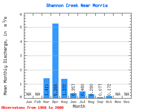
| Statistic | Jan | Feb | Mar | Apr | May | Jun | Jul | Aug | Sep | Oct | Nov | Dec | Annual |
|---|---|---|---|---|---|---|---|---|---|---|---|---|---|
| Mean | 1.41 | 5.26 | 1.37 | 0.36 | 0.48 | 0.28 | 0.08 | 0.17 | |||||
| Standard Deviation | 2.76 | 5.65 | 2.75 | 0.53 | 1.16 | 0.79 | 0.26 | 0.92 | |||||
| Min | 0.00 | 0.05 | 0.00 | 0.00 | 0.00 | 0.00 | 0.00 | 0.00 | |||||
| Max | 13.00 | 21.30 | 11.30 | 2.91 | 5.45 | 3.70 | 1.64 | 5.91 | |||||
| Coefficient of Variation | 1.96 | 1.07 | 2.00 | 1.47 | 2.42 | 2.82 | 3.42 | 5.34 |
 Return to R-Arctic Net Home Page