|
|
|||||||||||||||||
| Point ID: 3025 | Downloads | Plots | Site Data | Code: 05OF012 |
|
|
|||||||||||||||||
| Download | |
|---|---|
| Site Descriptor Information | Site Time Series Data |
| Link to all available data | |
| View: | Time Series | All |
| Units: | mm |
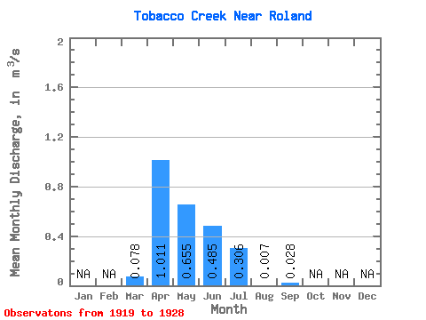
| Statistic | Jan | Feb | Mar | Apr | May | Jun | Jul | Aug | Sep | Oct | Nov | Dec | Annual |
|---|---|---|---|---|---|---|---|---|---|---|---|---|---|
| Mean | 0.08 | 1.01 | 0.66 | 0.48 | 0.31 | 0.01 | 0.03 | ||||||
| Standard Deviation | 1.09 | 1.36 | 0.71 | 0.74 | 0.01 | 0.04 | |||||||
| Min | 0.08 | 0.21 | 0.01 | 0.00 | 0.00 | 0.00 | 0.00 | ||||||
| Max | 0.08 | 3.29 | 4.38 | 1.92 | 2.14 | 0.03 | 0.07 | ||||||
| Coefficient of Variation | 1.08 | 2.08 | 1.47 | 2.43 | 1.71 | 1.30 |
 Return to R-Arctic Net Home Page