|
|
|||||||||||||||||
| Point ID: 3015 | Downloads | Plots | Site Data | Code: 05OE013 |
|
|
|||||||||||||||||
| Download | |
|---|---|
| Site Descriptor Information | Site Time Series Data |
| Link to all available data | |
| View: | Time Series | All |
| Units: | mm |
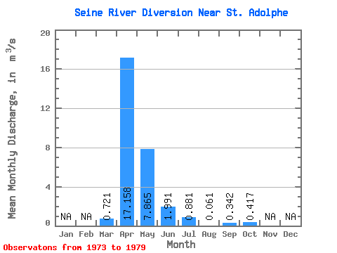
| Statistic | Jan | Feb | Mar | Apr | May | Jun | Jul | Aug | Sep | Oct | Nov | Dec | Annual |
|---|---|---|---|---|---|---|---|---|---|---|---|---|---|
| Mean | 0.72 | 17.16 | 7.87 | 1.99 | 0.88 | 0.06 | 0.34 | 0.42 | |||||
| Standard Deviation | 1.60 | 20.31 | 17.93 | 1.70 | 1.67 | 0.09 | 0.52 | 0.84 | |||||
| Min | 0.00 | 0.94 | 0.19 | 0.06 | 0.03 | 0.00 | 0.01 | 0.00 | |||||
| Max | 3.99 | 56.30 | 48.50 | 4.17 | 4.28 | 0.25 | 1.27 | 2.13 | |||||
| Coefficient of Variation | 2.23 | 1.18 | 2.28 | 0.85 | 1.89 | 1.56 | 1.52 | 2.02 |
 Return to R-Arctic Net Home Page