|
|
|||||||||||||||||
| Point ID: 3007 | Downloads | Plots | Site Data | Code: 05OE004 |
|
|
|||||||||||||||||
| Download | |
|---|---|
| Site Descriptor Information | Site Time Series Data |
| Link to all available data | |
| View: | Time Series | All |
| Units: | mm |
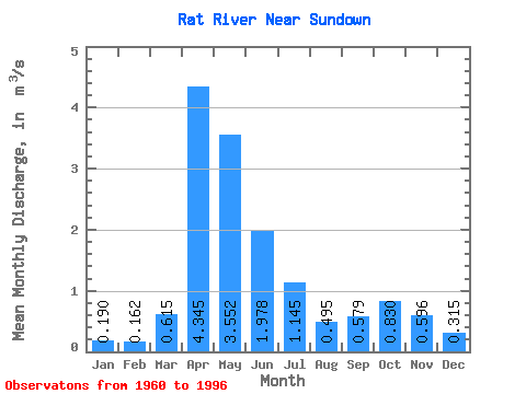
| Statistic | Jan | Feb | Mar | Apr | May | Jun | Jul | Aug | Sep | Oct | Nov | Dec | Annual |
|---|---|---|---|---|---|---|---|---|---|---|---|---|---|
| Mean | 0.19 | 0.16 | 0.61 | 4.34 | 3.55 | 1.98 | 1.15 | 0.49 | 0.58 | 0.83 | 0.60 | 0.32 | 1.23 |
| Standard Deviation | 0.11 | 0.10 | 0.61 | 2.99 | 2.95 | 1.49 | 1.24 | 0.63 | 0.66 | 0.75 | 0.45 | 0.23 | 0.58 |
| Min | 0.01 | 0.01 | 0.00 | 0.91 | 0.55 | 0.09 | 0.10 | 0.01 | 0.01 | 0.08 | 0.07 | 0.02 | 0.22 |
| Max | 0.57 | 0.45 | 2.98 | 11.70 | 10.80 | 5.90 | 5.82 | 2.90 | 2.52 | 3.58 | 2.51 | 1.00 | 2.75 |
| Coefficient of Variation | 0.57 | 0.64 | 0.99 | 0.69 | 0.83 | 0.75 | 1.08 | 1.27 | 1.14 | 0.90 | 0.76 | 0.72 | 0.47 |
 Return to R-Arctic Net Home Page