|
|
|||||||||||||||||
| Point ID: 3006 | Downloads | Plots | Site Data | Code: 05OE002 |
|
|
|||||||||||||||||
| Download | |
|---|---|
| Site Descriptor Information | Site Time Series Data |
| Link to all available data | |
| View: | Time Series | All |
| Units: | mm |
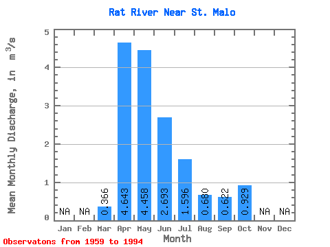
| Statistic | Jan | Feb | Mar | Apr | May | Jun | Jul | Aug | Sep | Oct | Nov | Dec | Annual |
|---|---|---|---|---|---|---|---|---|---|---|---|---|---|
| Mean | 0.37 | 4.64 | 4.46 | 2.69 | 1.60 | 0.68 | 0.62 | 0.93 | |||||
| Standard Deviation | 0.50 | 4.13 | 3.73 | 2.12 | 1.59 | 1.14 | 0.96 | 1.24 | |||||
| Min | 0.00 | 0.37 | 0.35 | 0.03 | 0.00 | 0.00 | 0.00 | 0.00 | |||||
| Max | 2.19 | 17.50 | 14.10 | 8.29 | 6.23 | 4.23 | 4.13 | 5.34 | |||||
| Coefficient of Variation | 1.35 | 0.89 | 0.84 | 0.79 | 0.99 | 1.68 | 1.55 | 1.33 |
 Return to R-Arctic Net Home Page