|
|
|||||||||||||||||
| Point ID: 2980 | Downloads | Plots | Site Data | Code: 05OC001 |
|
|
|||||||||||||||||
| Download | |
|---|---|
| Site Descriptor Information | Site Time Series Data |
| Link to all available data | |
| View: | Time Series | All |
| Units: | mm |
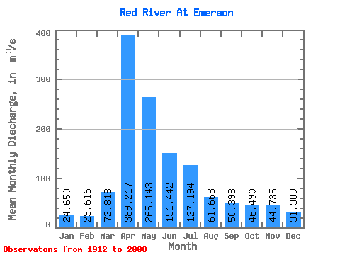
| Statistic | Jan | Feb | Mar | Apr | May | Jun | Jul | Aug | Sep | Oct | Nov | Dec | Annual |
|---|---|---|---|---|---|---|---|---|---|---|---|---|---|
| Mean | 24.65 | 23.62 | 72.82 | 389.22 | 265.14 | 151.44 | 127.19 | 61.67 | 50.40 | 46.49 | 44.73 | 31.39 | 107.81 |
| Standard Deviation | 17.81 | 16.83 | 92.64 | 298.39 | 346.89 | 132.67 | 134.83 | 88.20 | 53.61 | 38.10 | 48.53 | 24.95 | 77.97 |
| Min | 0.20 | 0.03 | 0.06 | 36.30 | 18.80 | 5.55 | 3.41 | 1.32 | 0.67 | 0.81 | 0.67 | 0.95 | 9.42 |
| Max | 63.00 | 69.30 | 580.00 | 1380.00 | 2060.00 | 720.00 | 794.00 | 765.00 | 325.00 | 170.00 | 390.00 | 115.00 | 370.20 |
| Coefficient of Variation | 0.72 | 0.71 | 1.27 | 0.77 | 1.31 | 0.88 | 1.06 | 1.43 | 1.06 | 0.82 | 1.08 | 0.80 | 0.72 |
 Return to R-Arctic Net Home Page