|
|
|||||||||||||||||
| Point ID: 2973 | Downloads | Plots | Site Data | Code: 05OB016 |
|
|
|||||||||||||||||
| Download | |
|---|---|
| Site Descriptor Information | Site Time Series Data |
| Link to all available data | |
| View: | Time Series | All |
| Units: | mm |
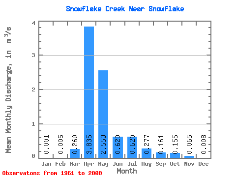
| Statistic | Jan | Feb | Mar | Apr | May | Jun | Jul | Aug | Sep | Oct | Nov | Dec | Annual |
|---|---|---|---|---|---|---|---|---|---|---|---|---|---|
| Mean | 0.00 | 0.01 | 0.26 | 3.83 | 2.55 | 0.62 | 0.62 | 0.28 | 0.16 | 0.15 | 0.07 | 0.01 | 0.73 |
| Standard Deviation | 0.01 | 0.02 | 0.46 | 5.10 | 4.99 | 0.88 | 2.36 | 0.76 | 0.49 | 0.45 | 0.21 | 0.04 | 1.06 |
| Min | 0.00 | 0.00 | 0.00 | 0.01 | 0.00 | 0.00 | 0.00 | 0.00 | 0.00 | 0.00 | 0.00 | 0.00 | 0.00 |
| Max | 0.04 | 0.14 | 2.11 | 18.90 | 26.80 | 3.48 | 15.00 | 3.93 | 2.83 | 2.00 | 1.13 | 0.22 | 5.46 |
| Coefficient of Variation | 5.51 | 4.89 | 1.77 | 1.33 | 1.95 | 1.42 | 3.80 | 2.74 | 3.02 | 2.91 | 3.24 | 4.48 | 1.46 |
 Return to R-Arctic Net Home Page