|
|
|||||||||||||||||
| Point ID: 2970 | Downloads | Plots | Site Data | Code: 05OB008 |
|
|
|||||||||||||||||
| Download | |
|---|---|
| Site Descriptor Information | Site Time Series Data |
| Link to all available data | |
| View: | Time Series | All |
| Units: | mm |
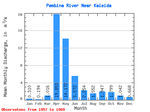
| Statistic | Jan | Feb | Mar | Apr | May | Jun | Jul | Aug | Sep | Oct | Nov | Dec | Annual |
|---|---|---|---|---|---|---|---|---|---|---|---|---|---|
| Mean | 0.31 | 0.19 | 1.02 | 19.85 | 14.17 | 5.57 | 2.25 | 1.55 | 1.95 | 1.80 | 1.04 | 0.67 | 4.17 |
| Standard Deviation | 0.49 | 0.37 | 1.50 | 26.93 | 14.30 | 4.45 | 2.19 | 1.29 | 3.13 | 3.07 | 1.37 | 0.95 | 3.94 |
| Min | 0.00 | 0.00 | 0.00 | 3.23 | 1.61 | 0.55 | 0.08 | 0.01 | 0.01 | 0.01 | 0.00 | 0.00 | 0.83 |
| Max | 1.55 | 1.24 | 4.99 | 95.00 | 47.40 | 13.40 | 7.52 | 3.81 | 11.30 | 11.40 | 4.75 | 3.06 | 14.52 |
| Coefficient of Variation | 1.58 | 1.91 | 1.48 | 1.36 | 1.01 | 0.80 | 0.97 | 0.83 | 1.61 | 1.71 | 1.32 | 1.42 | 0.94 |
 Return to R-Arctic Net Home Page