|
|
|||||||||||||||||
| Point ID: 2961 | Downloads | Plots | Site Data | Code: 05OA010 |
|
|
|||||||||||||||||
| Download | |
|---|---|
| Site Descriptor Information | Site Time Series Data |
| Link to all available data | |
| View: | Time Series | All |
| Units: | mm |
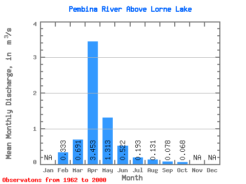
| Statistic | Jan | Feb | Mar | Apr | May | Jun | Jul | Aug | Sep | Oct | Nov | Dec | Annual |
|---|---|---|---|---|---|---|---|---|---|---|---|---|---|
| Mean | 0.33 | 0.69 | 3.45 | 1.31 | 0.52 | 0.19 | 0.13 | 0.08 | 0.07 | ||||
| Standard Deviation | 1.15 | 3.94 | 2.17 | 0.68 | 0.22 | 0.23 | 0.23 | 0.10 | |||||
| Min | 0.33 | 0.00 | 0.02 | 0.02 | 0.00 | 0.00 | 0.00 | 0.00 | 0.00 | ||||
| Max | 0.33 | 4.34 | 13.10 | 12.00 | 2.56 | 0.81 | 1.07 | 1.43 | 0.46 | ||||
| Coefficient of Variation | 1.67 | 1.14 | 1.66 | 1.31 | 1.16 | 1.74 | 2.95 | 1.49 |
 Return to R-Arctic Net Home Page