|
|
|||||||||||||||||
| Point ID: 2957 | Downloads | Plots | Site Data | Code: 05OA006 |
|
|
|||||||||||||||||
| Download | |
|---|---|
| Site Descriptor Information | Site Time Series Data |
| Link to all available data | |
| View: | Time Series | All |
| Units: | mm |
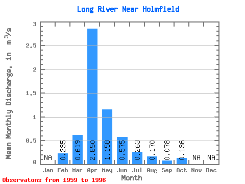
| Statistic | Jan | Feb | Mar | Apr | May | Jun | Jul | Aug | Sep | Oct | Nov | Dec | Annual |
|---|---|---|---|---|---|---|---|---|---|---|---|---|---|
| Mean | 0.23 | 0.62 | 2.85 | 1.16 | 0.57 | 0.26 | 0.17 | 0.08 | 0.14 | ||||
| Standard Deviation | 0.94 | 3.10 | 1.43 | 0.71 | 0.44 | 0.32 | 0.21 | 0.26 | |||||
| Min | 0.23 | 0.00 | 0.07 | 0.01 | 0.00 | 0.00 | 0.00 | 0.00 | 0.00 | ||||
| Max | 0.23 | 3.19 | 11.20 | 6.57 | 2.64 | 2.16 | 1.75 | 1.28 | 1.34 | ||||
| Coefficient of Variation | 1.51 | 1.09 | 1.23 | 1.24 | 1.66 | 1.88 | 2.73 | 1.88 |
 Return to R-Arctic Net Home Page