|
|
|||||||||||||||||
| Point ID: 2956 | Downloads | Plots | Site Data | Code: 05OA005 |
|
|
|||||||||||||||||
| Download | |
|---|---|
| Site Descriptor Information | Site Time Series Data |
| Link to all available data | |
| View: | Time Series | All |
| Units: | mm |
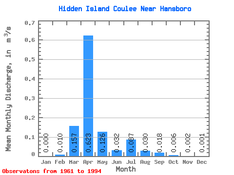
| Statistic | Jan | Feb | Mar | Apr | May | Jun | Jul | Aug | Sep | Oct | Nov | Dec | Annual |
|---|---|---|---|---|---|---|---|---|---|---|---|---|---|
| Mean | 0.00 | 0.01 | 0.16 | 0.62 | 0.13 | 0.03 | 0.09 | 0.03 | 0.02 | 0.01 | 0.00 | 0.00 | 0.09 |
| Standard Deviation | 0.00 | 0.06 | 0.40 | 0.87 | 0.26 | 0.07 | 0.30 | 0.10 | 0.08 | 0.02 | 0.01 | 0.01 | 0.09 |
| Min | 0.00 | 0.00 | 0.00 | 0.00 | 0.00 | 0.00 | 0.00 | 0.00 | 0.00 | 0.00 | 0.00 | 0.00 | 0.00 |
| Max | 0.00 | 0.32 | 2.19 | 3.31 | 1.24 | 0.27 | 1.62 | 0.48 | 0.47 | 0.13 | 0.03 | 0.03 | 0.39 |
| Coefficient of Variation | 5.75 | 2.51 | 1.40 | 2.09 | 2.06 | 3.41 | 3.27 | 4.54 | 3.99 | 3.53 | 5.45 | 1.01 |
 Return to R-Arctic Net Home Page