|
|
|||||||||||||||||
| Point ID: 2948 | Downloads | Plots | Site Data | Code: 05NG020 |
|
|
|||||||||||||||||
| Download | |
|---|---|
| Site Descriptor Information | Site Time Series Data |
| Link to all available data | |
| View: | Time Series | All |
| Units: | mm |
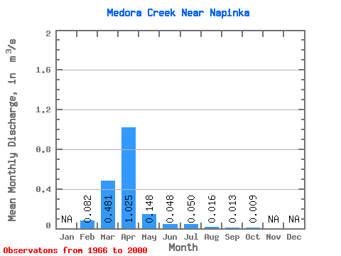
| Statistic | Jan | Feb | Mar | Apr | May | Jun | Jul | Aug | Sep | Oct | Nov | Dec | Annual |
|---|---|---|---|---|---|---|---|---|---|---|---|---|---|
| Mean | 0.08 | 0.48 | 1.02 | 0.15 | 0.05 | 0.05 | 0.02 | 0.01 | 0.01 | ||||
| Standard Deviation | 0.92 | 1.72 | 0.29 | 0.09 | 0.12 | 0.04 | 0.05 | 0.04 | |||||
| Min | 0.08 | 0.00 | 0.00 | 0.00 | 0.00 | 0.00 | 0.00 | 0.00 | 0.00 | ||||
| Max | 0.08 | 3.17 | 8.80 | 1.10 | 0.36 | 0.53 | 0.16 | 0.24 | 0.21 | ||||
| Coefficient of Variation | 1.92 | 1.68 | 1.95 | 1.81 | 2.44 | 2.66 | 3.72 | 4.48 |
 Return to R-Arctic Net Home Page