|
|
|||||||||||||||||
| Point ID: 2941 | Downloads | Plots | Site Data | Code: 05NG007 |
|
|
|||||||||||||||||
| Download | |
|---|---|
| Site Descriptor Information | Site Time Series Data |
| Link to all available data | |
| View: | Time Series | All |
| Units: | mm |
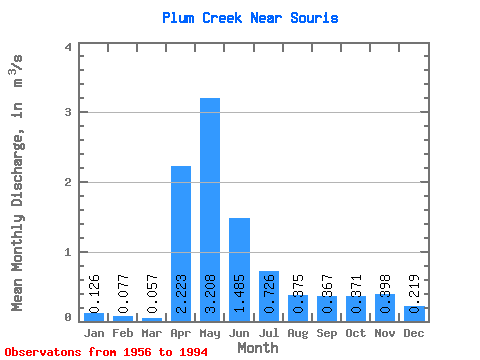
| Statistic | Jan | Feb | Mar | Apr | May | Jun | Jul | Aug | Sep | Oct | Nov | Dec | Annual |
|---|---|---|---|---|---|---|---|---|---|---|---|---|---|
| Mean | 0.13 | 0.08 | 0.06 | 2.22 | 3.21 | 1.48 | 0.73 | 0.38 | 0.37 | 0.37 | 0.40 | 0.22 | 1.02 |
| Standard Deviation | 0.52 | 0.33 | 0.13 | 8.83 | 6.30 | 2.88 | 1.48 | 0.84 | 0.85 | 0.96 | 0.91 | 0.67 | 1.93 |
| Min | 0.00 | 0.00 | 0.00 | 0.00 | 0.00 | 0.00 | 0.00 | 0.00 | 0.00 | 0.00 | 0.00 | 0.00 | 0.00 |
| Max | 2.60 | 1.65 | 0.75 | 55.40 | 28.80 | 12.30 | 6.15 | 4.05 | 3.78 | 4.96 | 4.29 | 3.26 | 8.96 |
| Coefficient of Variation | 4.11 | 4.29 | 2.33 | 3.97 | 1.97 | 1.94 | 2.04 | 2.23 | 2.31 | 2.58 | 2.29 | 3.07 | 1.90 |
 Return to R-Arctic Net Home Page