|
|
|||||||||||||||||
| Point ID: 2929 | Downloads | Plots | Site Data | Code: 05NF003 |
|
|
|||||||||||||||||
| Download | |
|---|---|
| Site Descriptor Information | Site Time Series Data |
| Link to all available data | |
| View: | Time Series | All |
| Units: | mm |
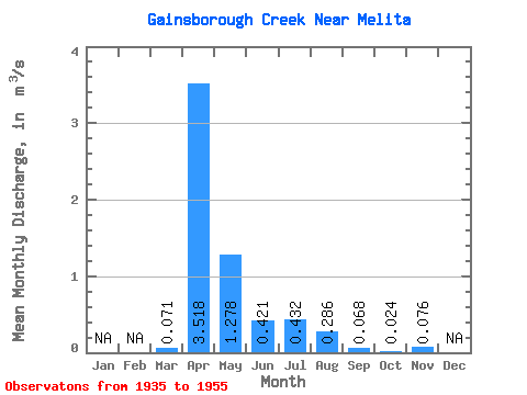
| Statistic | Jan | Feb | Mar | Apr | May | Jun | Jul | Aug | Sep | Oct | Nov | Dec | Annual |
|---|---|---|---|---|---|---|---|---|---|---|---|---|---|
| Mean | 0.07 | 3.52 | 1.28 | 0.42 | 0.43 | 0.29 | 0.07 | 0.02 | 0.08 | ||||
| Standard Deviation | 0.20 | 3.14 | 2.08 | 0.46 | 0.70 | 0.90 | 0.20 | 0.05 | |||||
| Min | 0.00 | 0.01 | 0.00 | 0.00 | 0.01 | 0.00 | 0.00 | 0.00 | 0.08 | ||||
| Max | 0.72 | 8.65 | 7.36 | 1.64 | 2.21 | 3.26 | 0.71 | 0.16 | 0.08 | ||||
| Coefficient of Variation | 2.80 | 0.89 | 1.63 | 1.10 | 1.62 | 3.13 | 2.88 | 2.29 |
 Return to R-Arctic Net Home Page