|
|
|||||||||||||||||
| Point ID: 2907 | Downloads | Plots | Site Data | Code: 05MG012 |
|
|
|||||||||||||||||
| Download | |
|---|---|
| Site Descriptor Information | Site Time Series Data |
| Link to all available data | |
| View: | Time Series | All |
| Units: | mm |
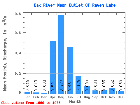
| Statistic | Jan | Feb | Mar | Apr | May | Jun | Jul | Aug | Sep | Oct | Nov | Dec | Annual |
|---|---|---|---|---|---|---|---|---|---|---|---|---|---|
| Mean | 0.02 | 0.01 | 0.01 | 0.52 | 0.78 | 0.46 | 0.18 | 0.08 | 0.03 | 0.04 | 0.05 | 0.03 | 0.23 |
| Standard Deviation | 0.04 | 0.03 | 0.02 | 1.18 | 0.85 | 0.37 | 0.23 | 0.13 | 0.04 | 0.07 | 0.11 | 0.07 | 0.23 |
| Min | 0.00 | 0.00 | 0.00 | 0.01 | 0.00 | 0.00 | 0.00 | 0.00 | 0.00 | 0.00 | 0.00 | 0.00 | 0.00 |
| Max | 0.08 | 0.06 | 0.06 | 3.42 | 2.14 | 0.91 | 0.70 | 0.38 | 0.11 | 0.20 | 0.25 | 0.15 | 0.58 |
| Coefficient of Variation | 2.24 | 2.24 | 2.78 | 2.27 | 1.10 | 0.81 | 1.30 | 1.60 | 1.27 | 1.93 | 2.17 | 2.24 | 0.99 |
 Return to R-Arctic Net Home Page