|
|
|||||||||||||||||
| Point ID: 2897 | Downloads | Plots | Site Data | Code: 05MG001 |
|
|
|||||||||||||||||
| Download | |
|---|---|
| Site Descriptor Information | Site Time Series Data |
| Link to all available data | |
| View: | Time Series | All |
| Units: | mm |
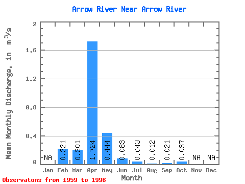
| Statistic | Jan | Feb | Mar | Apr | May | Jun | Jul | Aug | Sep | Oct | Nov | Dec | Annual |
|---|---|---|---|---|---|---|---|---|---|---|---|---|---|
| Mean | 0.22 | 0.20 | 1.72 | 0.44 | 0.08 | 0.04 | 0.01 | 0.02 | 0.04 | ||||
| Standard Deviation | 0.27 | 1.69 | 0.80 | 0.12 | 0.08 | 0.02 | 0.04 | 0.04 | |||||
| Min | 0.22 | 0.00 | 0.06 | 0.01 | 0.00 | 0.00 | 0.00 | 0.00 | 0.00 | ||||
| Max | 0.22 | 0.87 | 6.63 | 4.66 | 0.68 | 0.44 | 0.09 | 0.20 | 0.15 | ||||
| Coefficient of Variation | 1.32 | 0.98 | 1.80 | 1.48 | 1.89 | 1.89 | 2.02 | 0.95 |
 Return to R-Arctic Net Home Page