|
|
|||||||||||||||||
| Point ID: 2885 | Downloads | Plots | Site Data | Code: 05ME009 |
|
|
|||||||||||||||||
| Download | |
|---|---|
| Site Descriptor Information | Site Time Series Data |
| Link to all available data | |
| View: | Time Series | All |
| Units: | mm |
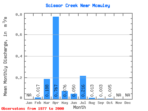
| Statistic | Jan | Feb | Mar | Apr | May | Jun | Jul | Aug | Sep | Oct | Nov | Dec | Annual |
|---|---|---|---|---|---|---|---|---|---|---|---|---|---|
| Mean | 0.02 | 0.19 | 0.77 | 0.08 | 0.05 | 0.22 | 0.01 | 0.00 | 0.01 | ||||
| Standard Deviation | 0.33 | 1.09 | 0.18 | 0.16 | 0.34 | 0.02 | 0.00 | 0.00 | |||||
| Min | 0.02 | 0.00 | 0.00 | 0.00 | 0.00 | 0.00 | 0.00 | 0.00 | 0.00 | ||||
| Max | 0.02 | 0.98 | 4.59 | 0.81 | 0.71 | 0.87 | 0.03 | 0.01 | 0.01 | ||||
| Coefficient of Variation | 1.73 | 1.42 | 2.35 | 3.17 | 1.58 | 1.20 | 1.28 | 0.78 |
 Return to R-Arctic Net Home Page