|
|
|||||||||||||||||
| Point ID: 2854 | Downloads | Plots | Site Data | Code: 05LL007 |
|
|
|||||||||||||||||
| Download | |
|---|---|
| Site Descriptor Information | Site Time Series Data |
| Link to all available data | |
| View: | Time Series | All |
| Units: | mm |
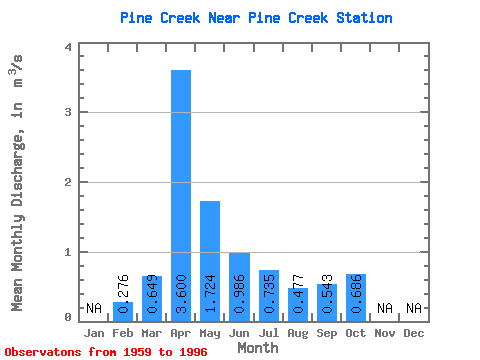
| Statistic | Jan | Feb | Mar | Apr | May | Jun | Jul | Aug | Sep | Oct | Nov | Dec | Annual |
|---|---|---|---|---|---|---|---|---|---|---|---|---|---|
| Mean | 0.28 | 0.65 | 3.60 | 1.72 | 0.99 | 0.73 | 0.48 | 0.54 | 0.69 | ||||
| Standard Deviation | 0.46 | 2.28 | 0.95 | 0.42 | 0.46 | 0.31 | 0.37 | 0.26 | |||||
| Min | 0.28 | 0.01 | 0.66 | 0.56 | 0.28 | 0.24 | 0.13 | 0.15 | 0.44 | ||||
| Max | 0.28 | 2.09 | 8.56 | 4.65 | 2.38 | 2.19 | 1.35 | 1.73 | 1.47 | ||||
| Coefficient of Variation | 0.71 | 0.63 | 0.55 | 0.42 | 0.62 | 0.66 | 0.69 | 0.37 |
 Return to R-Arctic Net Home Page