|
|
|||||||||||||||||
| Point ID: 285 | Downloads | Plots | Site Data | Code: 05BH006 |
|
|
|||||||||||||||||
| Download | |
|---|---|
| Site Descriptor Information | Site Time Series Data |
| Link to all available data | |
| View: | Time Series | All |
| Units: | mm |
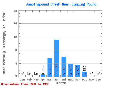
| Statistic | Jan | Feb | Mar | Apr | May | Jun | Jul | Aug | Sep | Oct | Nov | Dec | Annual |
|---|---|---|---|---|---|---|---|---|---|---|---|---|---|
| Mean | 0.79 | 5.65 | 11.18 | 5.99 | 3.97 | 3.61 | 1.56 | ||||||
| Standard Deviation | 4.68 | 13.32 | 8.31 | 4.14 | 5.98 | 1.45 | |||||||
| Min | 0.79 | 0.63 | 1.02 | 0.19 | 0.25 | 0.33 | 0.47 | ||||||
| Max | 0.79 | 16.00 | 43.70 | 27.40 | 13.70 | 21.90 | 4.20 | ||||||
| Coefficient of Variation | 0.83 | 1.19 | 1.39 | 1.04 | 1.66 | 0.93 |
 Return to R-Arctic Net Home Page