|
|
|||||||||||||||||
| Point ID: 2843 | Downloads | Plots | Site Data | Code: 05LJ040 |
|
|
|||||||||||||||||
| Download | |
|---|---|
| Site Descriptor Information | Site Time Series Data |
| Link to all available data | |
| View: | Time Series | All |
| Units: | mm |
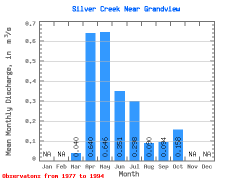
| Statistic | Jan | Feb | Mar | Apr | May | Jun | Jul | Aug | Sep | Oct | Nov | Dec | Annual |
|---|---|---|---|---|---|---|---|---|---|---|---|---|---|
| Mean | 0.04 | 0.64 | 0.65 | 0.35 | 0.30 | 0.09 | 0.09 | 0.16 | |||||
| Standard Deviation | 0.06 | 0.46 | 0.82 | 0.48 | 0.44 | 0.21 | 0.20 | 0.15 | |||||
| Min | 0.00 | 0.11 | 0.03 | 0.00 | 0.00 | 0.00 | 0.00 | 0.00 | |||||
| Max | 0.17 | 1.60 | 2.74 | 1.81 | 1.44 | 0.86 | 0.75 | 0.49 | |||||
| Coefficient of Variation | 1.38 | 0.71 | 1.27 | 1.38 | 1.47 | 2.35 | 2.15 | 0.94 |
 Return to R-Arctic Net Home Page