|
|
|||||||||||||||||
| Point ID: 2833 | Downloads | Plots | Site Data | Code: 05LJ024 |
|
|
|||||||||||||||||
| Download | |
|---|---|
| Site Descriptor Information | Site Time Series Data |
| Link to all available data | |
| View: | Time Series | All |
| Units: | mm |
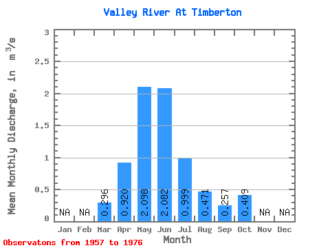
| Statistic | Jan | Feb | Mar | Apr | May | Jun | Jul | Aug | Sep | Oct | Nov | Dec | Annual |
|---|---|---|---|---|---|---|---|---|---|---|---|---|---|
| Mean | 0.30 | 0.92 | 2.10 | 2.08 | 1.00 | 0.47 | 0.26 | 0.41 | |||||
| Standard Deviation | 0.21 | 0.87 | 2.71 | 2.93 | 1.09 | 0.46 | 0.33 | 0.54 | |||||
| Min | 0.00 | 0.06 | 0.12 | 0.02 | 0.01 | 0.01 | 0.01 | 0.01 | |||||
| Max | 0.76 | 3.59 | 9.19 | 10.90 | 2.97 | 1.80 | 1.34 | 2.08 | |||||
| Coefficient of Variation | 0.72 | 0.95 | 1.29 | 1.41 | 1.09 | 0.97 | 1.27 | 1.31 |
 Return to R-Arctic Net Home Page