|
|
|||||||||||||||||
| Point ID: 2832 | Downloads | Plots | Site Data | Code: 05LJ022 |
|
|
|||||||||||||||||
| Download | |
|---|---|
| Site Descriptor Information | Site Time Series Data |
| Link to all available data | |
| View: | Time Series | All |
| Units: | mm |
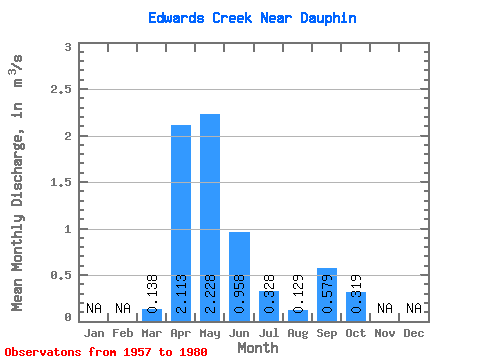
| Statistic | Jan | Feb | Mar | Apr | May | Jun | Jul | Aug | Sep | Oct | Nov | Dec | Annual |
|---|---|---|---|---|---|---|---|---|---|---|---|---|---|
| Mean | 0.14 | 2.11 | 2.23 | 0.96 | 0.33 | 0.13 | 0.58 | 0.32 | |||||
| Standard Deviation | 0.15 | 1.53 | 2.43 | 1.06 | 0.37 | 0.14 | 1.48 | 0.34 | |||||
| Min | 0.00 | 0.43 | 0.16 | 0.03 | 0.03 | 0.00 | 0.00 | 0.01 | |||||
| Max | 0.65 | 5.44 | 8.86 | 4.44 | 1.42 | 0.58 | 7.19 | 1.36 | |||||
| Coefficient of Variation | 1.11 | 0.72 | 1.09 | 1.10 | 1.12 | 1.08 | 2.56 | 1.07 |
 Return to R-Arctic Net Home Page