|
|
|||||||||||||||||
| Point ID: 2824 | Downloads | Plots | Site Data | Code: 05LJ014 |
|
|
|||||||||||||||||
| Download | |
|---|---|
| Site Descriptor Information | Site Time Series Data |
| Link to all available data | |
| View: | Time Series | All |
| Units: | mm |
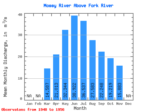
| Statistic | Jan | Feb | Mar | Apr | May | Jun | Jul | Aug | Sep | Oct | Nov | Dec | Annual |
|---|---|---|---|---|---|---|---|---|---|---|---|---|---|
| Mean | 14.59 | 21.01 | 32.34 | 38.92 | 36.54 | 27.58 | 22.25 | 19.22 | 15.88 | ||||
| Standard Deviation | 7.43 | 7.96 | 16.46 | 21.72 | 24.47 | 20.09 | 16.32 | 13.64 | 13.38 | ||||
| Min | 6.35 | 12.50 | 11.80 | 11.80 | 5.20 | 2.57 | 1.33 | 1.18 | 1.11 | ||||
| Max | 24.20 | 38.00 | 64.30 | 69.60 | 68.20 | 54.10 | 41.80 | 34.60 | 31.10 | ||||
| Coefficient of Variation | 0.51 | 0.38 | 0.51 | 0.56 | 0.67 | 0.73 | 0.73 | 0.71 | 0.84 |
 Return to R-Arctic Net Home Page