|
|
|||||||||||||||||
| Point ID: 2817 | Downloads | Plots | Site Data | Code: 05LJ004 |
|
|
|||||||||||||||||
| Download | |
|---|---|
| Site Descriptor Information | Site Time Series Data |
| Link to all available data | |
| View: | Time Series | All |
| Units: | mm |
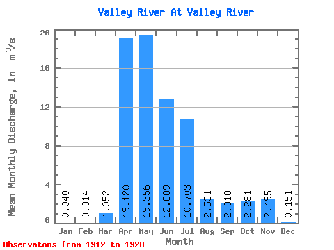
| Statistic | Jan | Feb | Mar | Apr | May | Jun | Jul | Aug | Sep | Oct | Nov | Dec | Annual |
|---|---|---|---|---|---|---|---|---|---|---|---|---|---|
| Mean | 0.04 | 0.01 | 1.05 | 19.12 | 19.36 | 12.89 | 10.70 | 2.53 | 2.01 | 2.28 | 2.50 | 0.15 | 3.54 |
| Standard Deviation | 0.05 | 0.02 | 2.08 | 18.48 | 16.30 | 11.06 | 11.57 | 2.51 | 1.71 | 1.74 | 3.49 | 0.09 | 1.86 |
| Min | 0.00 | 0.00 | 0.00 | 2.27 | 1.50 | 2.15 | 1.30 | 0.25 | 0.44 | 0.58 | 0.34 | 0.00 | 0.91 |
| Max | 0.11 | 0.06 | 5.67 | 50.70 | 66.40 | 39.60 | 41.10 | 8.07 | 6.02 | 6.36 | 11.90 | 0.28 | 5.80 |
| Coefficient of Variation | 1.31 | 1.68 | 1.98 | 0.97 | 0.84 | 0.86 | 1.08 | 0.99 | 0.85 | 0.76 | 1.40 | 0.61 | 0.53 |
 Return to R-Arctic Net Home Page