|
|
|||||||||||||||||
| Point ID: 2810 | Downloads | Plots | Site Data | Code: 05LG005 |
|
|
|||||||||||||||||
| Download | |
|---|---|
| Site Descriptor Information | Site Time Series Data |
| Link to all available data | |
| View: | Time Series | All |
| Units: | mm |
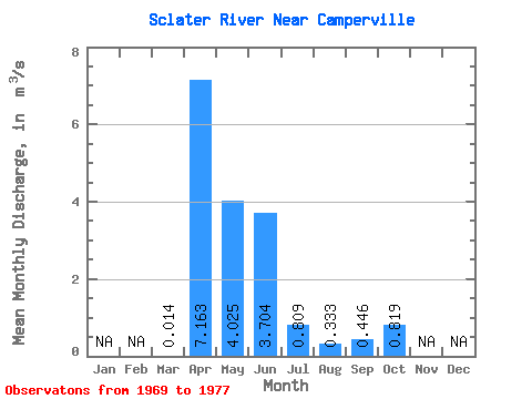
| Statistic | Jan | Feb | Mar | Apr | May | Jun | Jul | Aug | Sep | Oct | Nov | Dec | Annual |
|---|---|---|---|---|---|---|---|---|---|---|---|---|---|
| Mean | 0.01 | 7.16 | 4.03 | 3.70 | 0.81 | 0.33 | 0.45 | 0.82 | |||||
| Standard Deviation | 0.01 | 4.79 | 4.39 | 4.43 | 1.08 | 0.64 | 0.62 | 0.70 | |||||
| Min | 0.00 | 0.32 | 0.37 | 0.03 | 0.03 | 0.00 | 0.00 | 0.00 | |||||
| Max | 0.04 | 14.40 | 13.60 | 13.20 | 3.41 | 2.02 | 1.81 | 2.07 | |||||
| Coefficient of Variation | 0.96 | 0.67 | 1.09 | 1.20 | 1.33 | 1.93 | 1.40 | 0.86 |
 Return to R-Arctic Net Home Page