|
|
|||||||||||||||||
| Point ID: 2809 | Downloads | Plots | Site Data | Code: 05LG004 |
|
|
|||||||||||||||||
| Download | |
|---|---|
| Site Descriptor Information | Site Time Series Data |
| Link to all available data | |
| View: | Time Series | All |
| Units: | mm |
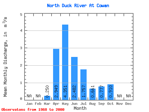
| Statistic | Jan | Feb | Mar | Apr | May | Jun | Jul | Aug | Sep | Oct | Nov | Dec | Annual |
|---|---|---|---|---|---|---|---|---|---|---|---|---|---|
| Mean | 0.25 | 2.95 | 4.35 | 2.48 | 1.76 | 0.66 | 0.78 | 0.91 | |||||
| Standard Deviation | 0.19 | 2.01 | 3.50 | 2.34 | 2.32 | 0.78 | 1.04 | 0.85 | |||||
| Min | 0.01 | 0.69 | 0.40 | 0.11 | 0.06 | 0.05 | 0.06 | 0.17 | |||||
| Max | 0.71 | 8.27 | 14.00 | 9.11 | 12.40 | 3.50 | 4.44 | 3.90 | |||||
| Coefficient of Variation | 0.74 | 0.68 | 0.80 | 0.94 | 1.32 | 1.18 | 1.33 | 0.93 |
 Return to R-Arctic Net Home Page