|
|
|||||||||||||||||
| Point ID: 2807 | Downloads | Plots | Site Data | Code: 05LG002 |
|
|
|||||||||||||||||
| Download | |
|---|---|
| Site Descriptor Information | Site Time Series Data |
| Link to all available data | |
| View: | Time Series | All |
| Units: | mm |
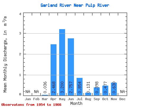
| Statistic | Jan | Feb | Mar | Apr | May | Jun | Jul | Aug | Sep | Oct | Nov | Dec | Annual |
|---|---|---|---|---|---|---|---|---|---|---|---|---|---|
| Mean | 0.04 | 2.47 | 3.20 | 2.76 | 0.85 | 0.13 | 0.40 | 0.48 | 0.63 | ||||
| Standard Deviation | 0.04 | 2.05 | 2.34 | 3.12 | 1.12 | 0.15 | 0.62 | 0.81 | |||||
| Min | 0.00 | 0.34 | 0.31 | 0.10 | 0.00 | 0.00 | 0.00 | 0.00 | 0.63 | ||||
| Max | 0.10 | 5.88 | 7.91 | 10.30 | 3.32 | 0.46 | 1.84 | 2.21 | 0.63 | ||||
| Coefficient of Variation | 1.19 | 0.83 | 0.73 | 1.13 | 1.31 | 1.11 | 1.57 | 1.69 |
 Return to R-Arctic Net Home Page