|
|
|||||||||||||||||
| Point ID: 2798 | Downloads | Plots | Site Data | Code: 05LE003 |
|
|
|||||||||||||||||
| Download | |
|---|---|
| Site Descriptor Information | Site Time Series Data |
| Link to all available data | |
| View: | Time Series | All |
| Units: | mm |
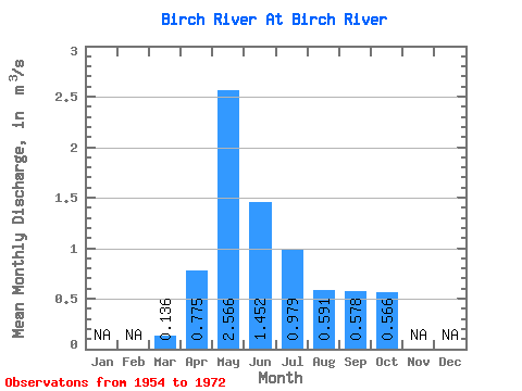
| Statistic | Jan | Feb | Mar | Apr | May | Jun | Jul | Aug | Sep | Oct | Nov | Dec | Annual |
|---|---|---|---|---|---|---|---|---|---|---|---|---|---|
| Mean | 0.14 | 0.78 | 2.57 | 1.45 | 0.98 | 0.59 | 0.58 | 0.57 | |||||
| Standard Deviation | 0.10 | 0.61 | 1.77 | 1.15 | 0.77 | 0.65 | 0.59 | 0.59 | |||||
| Min | 0.00 | 0.04 | 0.31 | 0.18 | 0.13 | 0.12 | 0.10 | 0.16 | |||||
| Max | 0.26 | 2.10 | 6.43 | 4.23 | 2.71 | 2.69 | 2.01 | 2.69 | |||||
| Coefficient of Variation | 0.71 | 0.79 | 0.69 | 0.79 | 0.79 | 1.10 | 1.02 | 1.04 |
 Return to R-Arctic Net Home Page