|
|
|||||||||||||||||
| Point ID: 2795 | Downloads | Plots | Site Data | Code: 05LD001 |
|
|
|||||||||||||||||
| Download | |
|---|---|
| Site Descriptor Information | Site Time Series Data |
| Link to all available data | |
| View: | Time Series | All |
| Units: | mm |
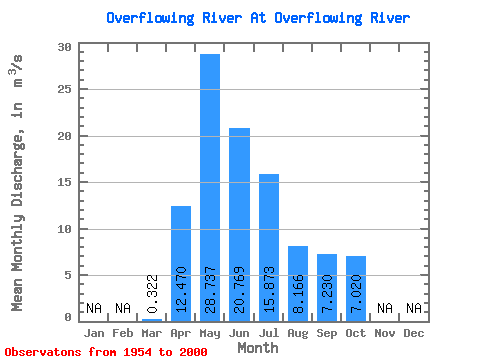
| Statistic | Jan | Feb | Mar | Apr | May | Jun | Jul | Aug | Sep | Oct | Nov | Dec | Annual |
|---|---|---|---|---|---|---|---|---|---|---|---|---|---|
| Mean | 0.32 | 12.47 | 28.74 | 20.77 | 15.87 | 8.17 | 7.23 | 7.02 | |||||
| Standard Deviation | 0.57 | 7.96 | 20.50 | 17.39 | 15.38 | 9.47 | 8.99 | 5.72 | |||||
| Min | 0.00 | 0.88 | 2.50 | 0.41 | 0.11 | 0.02 | 0.01 | 0.01 | |||||
| Max | 3.64 | 34.60 | 74.00 | 72.10 | 66.90 | 56.50 | 38.40 | 23.20 | |||||
| Coefficient of Variation | 1.78 | 0.64 | 0.71 | 0.84 | 0.97 | 1.16 | 1.24 | 0.81 |
 Return to R-Arctic Net Home Page