|
|
|||||||||||||||||
| Point ID: 2790 | Downloads | Plots | Site Data | Code: 05KJ001 |
|
|
|||||||||||||||||
| Download | |
|---|---|
| Site Descriptor Information | Site Time Series Data |
| Link to all available data | |
| View: | Time Series | All |
| Units: | mm |
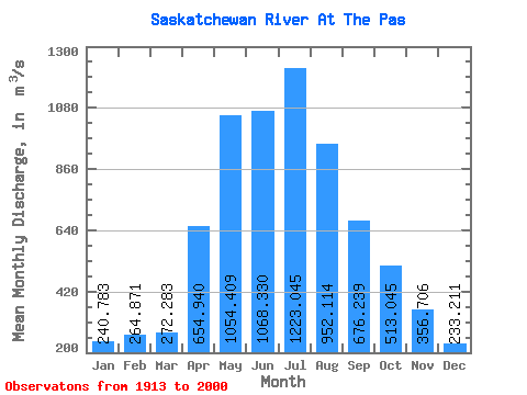
| Statistic | Jan | Feb | Mar | Apr | May | Jun | Jul | Aug | Sep | Oct | Nov | Dec | Annual |
|---|---|---|---|---|---|---|---|---|---|---|---|---|---|
| Mean | 240.78 | 264.87 | 272.28 | 654.94 | 1054.41 | 1068.33 | 1223.05 | 952.11 | 676.24 | 513.04 | 356.71 | 233.21 | 635.85 |
| Standard Deviation | 131.43 | 169.00 | 164.70 | 227.68 | 453.75 | 469.25 | 534.34 | 469.42 | 343.49 | 260.35 | 170.58 | 112.42 | 180.22 |
| Min | 54.70 | 53.80 | 63.80 | 130.00 | 388.00 | 288.00 | 305.00 | 265.00 | 242.00 | 124.00 | 104.00 | 63.90 | 305.78 |
| Max | 487.00 | 627.00 | 611.00 | 1190.00 | 2330.00 | 2850.00 | 2650.00 | 2680.00 | 1980.00 | 1680.00 | 1150.00 | 814.00 | 1171.25 |
| Coefficient of Variation | 0.55 | 0.64 | 0.60 | 0.35 | 0.43 | 0.44 | 0.44 | 0.49 | 0.51 | 0.51 | 0.48 | 0.48 | 0.28 |
 Return to R-Arctic Net Home Page