|
|
|||||||||||||||||
| Point ID: 279 | Downloads | Plots | Site Data | Code: 05BG009 |
|
|
|||||||||||||||||
| Download | |
|---|---|
| Site Descriptor Information | Site Time Series Data |
| Link to all available data | |
| View: | Time Series | All |
| Units: | mm |
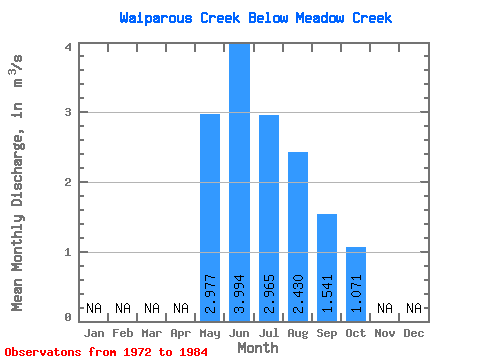
| Statistic | Jan | Feb | Mar | Apr | May | Jun | Jul | Aug | Sep | Oct | Nov | Dec | Annual |
|---|---|---|---|---|---|---|---|---|---|---|---|---|---|
| Mean | 2.98 | 3.99 | 2.96 | 2.43 | 1.54 | 1.07 | |||||||
| Standard Deviation | 1.56 | 1.13 | 2.30 | 1.88 | 0.58 | 0.26 | |||||||
| Min | 1.19 | 2.45 | 0.94 | 0.75 | 0.76 | 0.59 | |||||||
| Max | 6.21 | 5.26 | 7.35 | 6.80 | 2.28 | 1.37 | |||||||
| Coefficient of Variation | 0.53 | 0.28 | 0.77 | 0.77 | 0.38 | 0.24 |
 Return to R-Arctic Net Home Page