|
|
|||||||||||||||||
| Point ID: 2788 | Downloads | Plots | Site Data | Code: 04AC007 |
|
|
|||||||||||||||||
| Download | |
|---|---|
| Site Descriptor Information | Site Time Series Data |
| Link to all available data | |
| View: | Time Series | All |
| Units: | mm |
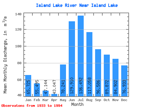
| Statistic | Jan | Feb | Mar | Apr | May | Jun | Jul | Aug | Sep | Oct | Nov | Dec | Annual |
|---|---|---|---|---|---|---|---|---|---|---|---|---|---|
| Mean | 65.72 | 55.49 | 47.14 | 43.05 | 78.24 | 129.91 | 136.49 | 117.06 | 96.59 | 89.87 | 84.90 | 76.93 | 86.79 |
| Standard Deviation | 22.44 | 17.77 | 13.28 | 11.41 | 26.57 | 52.96 | 56.19 | 45.97 | 36.55 | 40.47 | 38.49 | 30.64 | 23.54 |
| Min | 23.70 | 16.70 | 15.10 | 14.40 | 36.50 | 54.30 | 53.70 | 44.90 | 35.80 | 31.70 | 28.60 | 25.30 | 41.63 |
| Max | 134.00 | 123.00 | 99.30 | 88.00 | 141.00 | 284.00 | 276.00 | 233.00 | 211.00 | 222.00 | 209.00 | 174.00 | 141.51 |
| Coefficient of Variation | 0.34 | 0.32 | 0.28 | 0.27 | 0.34 | 0.41 | 0.41 | 0.39 | 0.38 | 0.45 | 0.45 | 0.40 | 0.27 |
 Return to R-Arctic Net Home Page