|
|
|||||||||||||||||
| Point ID: 2761 | Downloads | Plots | Site Data | Code: 10BE001 |
|
|
|||||||||||||||||
| Download | |
|---|---|
| Site Descriptor Information | Site Time Series Data |
| Link to all available data | |
| View: | Time Series | All |
| Units: | mm |
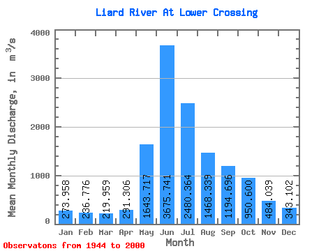
| Statistic | Jan | Feb | Mar | Apr | May | Jun | Jul | Aug | Sep | Oct | Nov | Dec | Annual |
|---|---|---|---|---|---|---|---|---|---|---|---|---|---|
| Mean | 273.96 | 236.78 | 219.96 | 291.31 | 1643.72 | 3675.74 | 2480.36 | 1468.34 | 1194.70 | 950.60 | 484.04 | 343.10 | 1121.90 |
| Standard Deviation | 60.57 | 49.66 | 45.20 | 116.46 | 506.98 | 944.61 | 747.06 | 362.72 | 302.02 | 268.93 | 121.91 | 77.29 | 178.84 |
| Min | 172.00 | 140.00 | 128.00 | 167.00 | 745.00 | 1930.00 | 1240.00 | 761.00 | 667.00 | 468.00 | 262.00 | 190.00 | 747.42 |
| Max | 431.00 | 368.00 | 368.00 | 812.00 | 2860.00 | 6210.00 | 4490.00 | 2600.00 | 1940.00 | 1680.00 | 853.00 | 555.00 | 1621.50 |
| Coefficient of Variation | 0.22 | 0.21 | 0.20 | 0.40 | 0.31 | 0.26 | 0.30 | 0.25 | 0.25 | 0.28 | 0.25 | 0.23 | 0.16 |
 Return to R-Arctic Net Home Page