|
|
|||||||||||||||||
| Point ID: 276 | Downloads | Plots | Site Data | Code: 05BG004 |
|
|
|||||||||||||||||
| Download | |
|---|---|
| Site Descriptor Information | Site Time Series Data |
| Link to all available data | |
| View: | Time Series | All |
| Units: | mm |
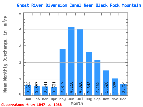
| Statistic | Jan | Feb | Mar | Apr | May | Jun | Jul | Aug | Sep | Oct | Nov | Dec | Annual |
|---|---|---|---|---|---|---|---|---|---|---|---|---|---|
| Mean | 0.62 | 0.56 | 0.54 | 0.53 | 2.82 | 4.12 | 4.03 | 2.64 | 2.16 | 1.52 | 1.02 | 0.71 | 1.79 |
| Standard Deviation | 0.07 | 0.05 | 0.10 | 0.12 | 1.28 | 2.35 | 1.73 | 0.81 | 0.96 | 0.47 | 0.24 | 0.11 | 0.42 |
| Min | 0.55 | 0.48 | 0.43 | 0.28 | 1.53 | 0.17 | 0.85 | 1.29 | 1.21 | 0.93 | 0.67 | 0.58 | 1.04 |
| Max | 0.70 | 0.60 | 0.72 | 0.88 | 6.25 | 8.45 | 7.25 | 4.30 | 4.94 | 2.60 | 1.42 | 0.86 | 2.07 |
| Coefficient of Variation | 0.11 | 0.08 | 0.18 | 0.23 | 0.46 | 0.57 | 0.43 | 0.30 | 0.44 | 0.31 | 0.23 | 0.15 | 0.24 |
 Return to R-Arctic Net Home Page