|
|
|||||||||||||||||
| Point ID: 2752 | Downloads | Plots | Site Data | Code: 10AC003 |
|
|
|||||||||||||||||
| Download | |
|---|---|
| Site Descriptor Information | Site Time Series Data |
| Link to all available data | |
| View: | Time Series | All |
| Units: | mm |
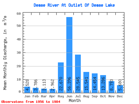
| Statistic | Jan | Feb | Mar | Apr | May | Jun | Jul | Aug | Sep | Oct | Nov | Dec | Annual |
|---|---|---|---|---|---|---|---|---|---|---|---|---|---|
| Mean | 4.53 | 3.79 | 3.11 | 2.96 | 22.67 | 56.40 | 28.55 | 15.54 | 14.45 | 13.29 | 8.79 | 5.68 | 15.48 |
| Standard Deviation | 0.98 | 0.75 | 0.60 | 0.46 | 10.33 | 22.64 | 14.56 | 6.97 | 6.88 | 4.94 | 3.05 | 1.40 | 3.58 |
| Min | 2.71 | 2.43 | 2.02 | 2.33 | 5.41 | 18.90 | 8.81 | 5.43 | 4.91 | 4.98 | 4.73 | 3.33 | 7.02 |
| Max | 6.27 | 4.98 | 4.23 | 4.08 | 54.80 | 104.00 | 86.40 | 35.10 | 31.00 | 23.90 | 17.60 | 8.67 | 25.28 |
| Coefficient of Variation | 0.22 | 0.20 | 0.19 | 0.15 | 0.46 | 0.40 | 0.51 | 0.45 | 0.48 | 0.37 | 0.35 | 0.25 | 0.23 |
 Return to R-Arctic Net Home Page